
By Glynn Wilson –
Winter is coming and the West Coast faces a powerful weather system that may reshape the landscape and test the region’s aging infrastructure.
A powerful El Niño is rapidly strengthening in the tropical Pacific, and federal climate scientists are now putting the odds of a very strong El Niño at greater than 90 percent for the fall and winter of 2026–27. NOAA says the developing event could rank among the strongest observed since modern records began in 1950.
The good news is it could rebuild mountain snowpack and refill water reservoirs. The down side will be the threat of major floods and mudslides on land where wildfires have cleared ground holding vegetation.
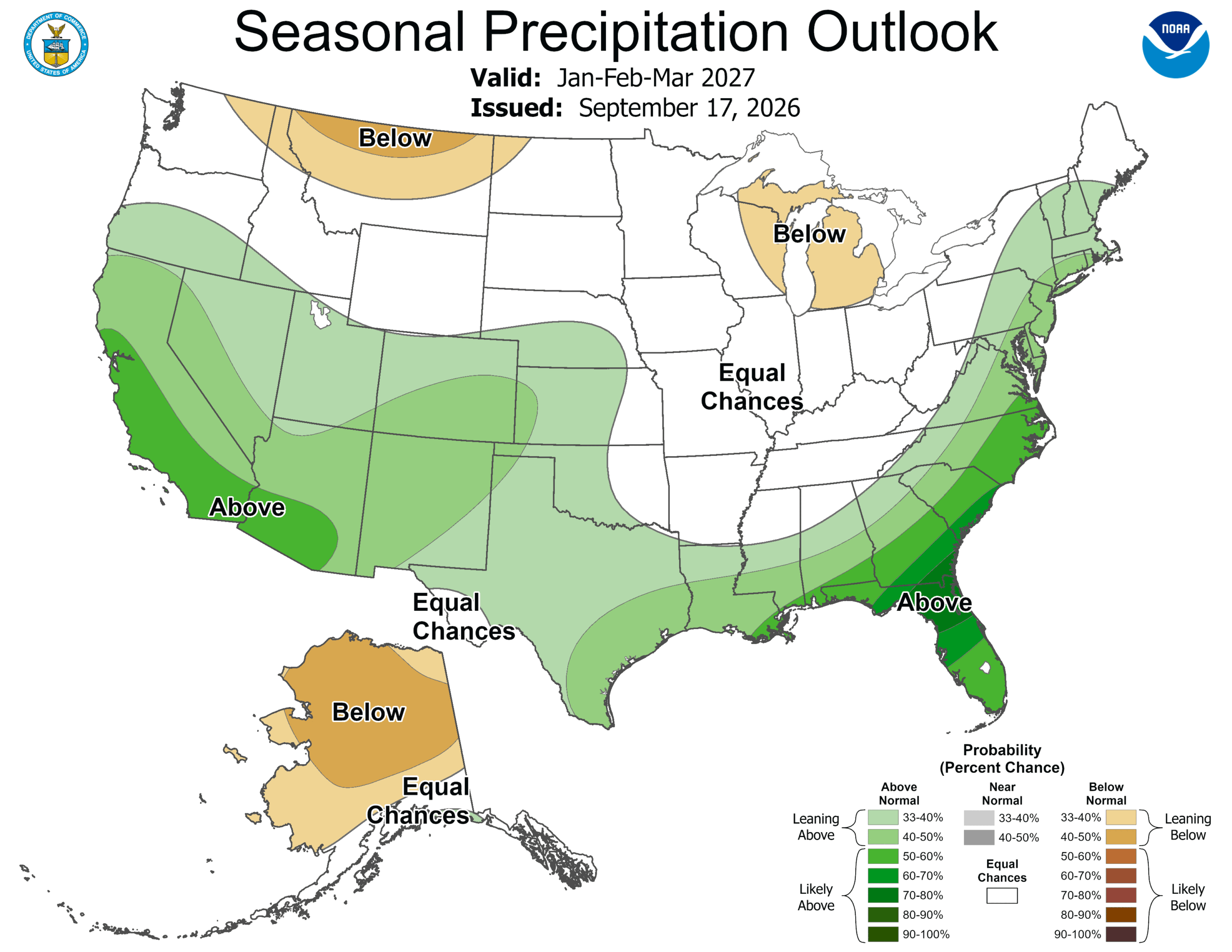
NOAA’s latest seasonal outlook calls for above-normal precipitation across California during the core winter months, with the signal particularly pronounced from January through March in Northern California. Other major forecast models are pointing in the same general direction.
That does not mean forecasters can predict exactly how many inches of rain will fall in San Francisco, Sacramento, the Sierra Nevada or the foothills. Seasonal forecasts deal in probabilities.
But the ingredients are increasingly unusual.
An El Niño With Historic Potential
El Niño occurs when unusually warm ocean water develops across the central and eastern tropical Pacific, disrupting atmospheric circulation around the globe.
This year’s event is already exceptionally warm.
NOAA’s September 10 assessment reported sea-surface-temperature anomalies exceeding 3 degrees Celsius in the eastern equatorial Pacific, while the Niño-3.4 region was 1.8°C above average. NOAA gave the developing event a greater than 90 percent chance of reaching “very strong” status during the Northern Hemisphere fall and winter.
NOAA’s forecast also puts substantial odds on an event that could exceed the strength of previous El Niños dating back to 1950.
The National Oceanic and Atmospheric Administration is not saying that a record wet winter is guaranteed. It is saying that the atmospheric setup is increasingly favorable for major precipitation.
And California has seen this movie before.
Remember 1982–83 and 1997–98
Two of the strongest El Niño events of the modern era — 1982–83 and 1997–98 — produced exceptionally wet conditions across much of California.
The state’s history with those winters is a reminder of both sides of the equation.
Water managers welcome enormous precipitation totals after dry years.
But when too much water arrives too quickly, the same storms can produce catastrophic flooding, mudslides, debris flows, coastal erosion and infrastructure damage.
California’s current preparations reflect that concern.
Gov. Gavin Newsom declared a statewide emergency on Sept. 21 in anticipation of potentially severe El Niño-related weather, directing state agencies to prepare for flooding, landslides, coastal hazards and other winter impacts.
The state is preparing millions of sandbags and other flood-control resources while urging communities to prepare before the major storms arrive.
Northern California Could Have a Complicated Winter
For Northern California, however, there is an important wrinkle. A very wet winter does not necessarily mean an enormous Sierra snowpack. The same atmospheric pattern capable of delivering abundant precipitation can also produce warmer-than-normal temperatures.
That distinction could become critical in the Sierra Nevada.
If storms arrive with relatively mild temperatures, some precipitation that might otherwise fall as snow could instead fall as rain at middle and lower elevations. That means Northern California could experience a winter with enormous amounts of precipitation while still seeing an uneven snowpack.
For reservoirs, rivers and groundwater, that can be beneficial. For the long-term water supply system, however, snow is particularly valuable because it acts as a natural reservoir, storing water in the mountains and releasing it gradually during spring and summer.
The Sierra snowpack is therefore likely to be one of the most important things to watch as the season develops.
Atmospheric Rivers Could Become the Wild Card
El Niño does not create individual storms on command. Instead, it changes the odds of particular atmospheric patterns developing.
One of the most consequential phenomena for California is the atmospheric river — a long, narrow corridor of concentrated water vapor that can transport enormous quantities of moisture from the Pacific toward the West Coast.
When an atmospheric river strikes California at the right angle, precipitation can continue for hours or days.
A sequence of powerful storms can rapidly fill rivers and reservoirs.
When those storms collide with already saturated soil, however, flooding and landslides can follow.
That is particularly relevant in the foothills and mountains of Northern California, where steep terrain, wildfire scars and narrow transportation corridors can make communities vulnerable.
A Potential Water Bonanza
There is also an enormous upside. California’s water system has been shaped by a fundamental problem: precipitation is highly variable. One winter can bring extraordinary amounts of water while another produces drought.
A very wet 2026–27 winter could improve reservoir storage, replenish groundwater and reduce drought stress across parts of the state. That would be especially significant following years in which California has repeatedly experienced extreme swings between drought, atmospheric-river flooding and heat.
According to the federal drought assessment released in August, only about 7 percent of California was experiencing drought at that point, although 58 percent of the state was classified as abnormally dry.
A major wet season could therefore provide substantial relief. But California’s water system cannot simply assume that one wet winter solves every long-term water problem.
Groundwater overdraft, aging infrastructure, ecological requirements, population growth and increasingly volatile weather patterns remain separate challenges.
The Fire Season Connection
There is another irony.
Northern California could enter the winter with elevated wildfire concerns and then abruptly transition into flood concerns.
Federal officials were forecasting above-normal significant wildfire potential in parts of Northern California and Nevada during September, with fire potential expected to decrease later in the fall.
When intense rain falls on landscapes recently affected by wildfire, the danger does not necessarily disappear.
It can change.
Vegetation loss and altered soil conditions can increase runoff and erosion, turning steep slopes into potential sources of mud and debris.
For communities in the Sierra foothills, that means emergency planning cannot stop when fire season ends.
What Happens in Yosemite Country?
The implications could be particularly dramatic around the Sierra Nevada and Yosemite region. A wet winter can transform the landscape.
Creeks become torrents. Waterfalls swell. Rivers rise. Meadows remain saturated. Snow transforms the high country.
But winter travel can become considerably more difficult.
Heavy precipitation at lower elevations can mean flooding and rockslides, while colder storms at higher elevations can produce enormous snow accumulations.
The difference between a beautiful Sierra snowstorm and a dangerous winter event can sometimes be only a matter of temperature and storm trajectory.
For communities such as those scattered through the Sierra foothills, preparation may be more important than attempting to predict the exact outcome.
Don’t Confuse “Very Strong El Niño” With “Guaranteed Record Rain”
There is an important caveat to all of this.
El Niño is not a rain switch.
Historically, strong El Niño events have produced different results in different parts of California.
The August federal drought assessment noted that two of the three strongest El Niños since 1950 — 1982–83 and 1997–98 — produced extreme wet conditions across California and Nevada, while the 2015–16 event produced precipitation closer to normal.
And even within a single winter, one part of California can receive extraordinary precipitation while another receives considerably less. That is why meteorologists emphasize probabilities rather than certainties.
Still, the convergence of observations and models is notable.
NOAA’s climate scientists, NOAA’s Geophysical Fluid Dynamics Laboratory and other forecasting systems are all indicating an unusually powerful El Niño is developing. NOAA’s GFDL reported that all 30 members of its September ensemble forecast showed an event competing with, or potentially surpassing, the strongest historical events.
__
If you like this story and independent radio news service you can help Fund Yosemite Radio, KNHA 100.9 FM with GoFundMe.