|
Getting your Trinity Audio player ready…
|
Staff Report –
Weather forecasters say a powerful El Niño weather pattern could form later this year, with a chance of becoming one of the strongest in three decades. The winds above the Pacific are shifting, the ocean is releasing stored-up heat, and a cascade of effects on rain, droughts and wildfires could be on its way.
The National Oceanic and Atmospheric Administration says there’s a roughly 60 percent chance of an El Niño developing between May and July. That’s a major reason scientists now say next year could surpass 2024 as the planet’s warmest year since modern records began in the mid-19th century.
El Niño and La Niña are the opposite phases of a natural climate cycle that has been active in the Pacific for thousands of years. They appear at irregular intervals, and no two events are ever the same. But Earth’s steady warming from the burning of fossil fuels is also influencing the way these episodes shape the weather around the globe.
“We are now in a different base line climate,” said Clara Deser, a senior scientist at the National Center for Atmospheric Research in Boulder, Colo. That means past El Niños don’t necessarily tell us how the El Niños of the future will look, Dr. Deser said.
It was a fairly dry winter in California, and the early signs are pointing toward a strong El Nino developing by winter 2026-27. That has real implications for Northern California’s rain season.
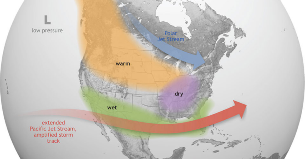
El Nino occurs when sea surface temperatures across the equatorial Pacific run warmer than normal. That warmer ocean drives changes in the jet stream and storm tracks, which typically means more rain for California and the Southwest. La Nina, the opposite phase, tends to bring drier conditions, which is what played out this past winter.

What forecasters are watching right now is a Kelvin wave, a mass of unusually warm water moving eastward about 100 to 200 meters below the surface of the Pacific. Early April data showed that water running roughly five degrees Celsius above normal.
When it upwells off South America in the coming weeks, it is expected to trigger El Nino conditions that could intensify into the very strong category, meaning sea surface temperatures more than two degrees Celsius above normal.
Only three winters in recorded history have qualified as very strong El Nino events: 1982-83, 1997-98, and 2015-16. Two of those were historically wet for Northern California. Sacramento received more than 34 inches of rain in 1982-83. But 2015-16, also a super El Nino year, came in below average, which is a useful reminder that the sample size is small and nothing is guaranteed.
What forecasters do agree on is that El Nino years trend wetter than normal in California across the board. Whether this one lives up to the hype remains to be seen.
Reporting from the New York Times and Active NorCal.